Maps encompass all of Carbon County’s outdoor assets & activities
The Carbon County Visitors’ Council is excited to launch the Carbon County Recreation and Trail Maps. Check out these great interactive recreation and trail maps that are inclusive of all Carbon County outdoor resources.
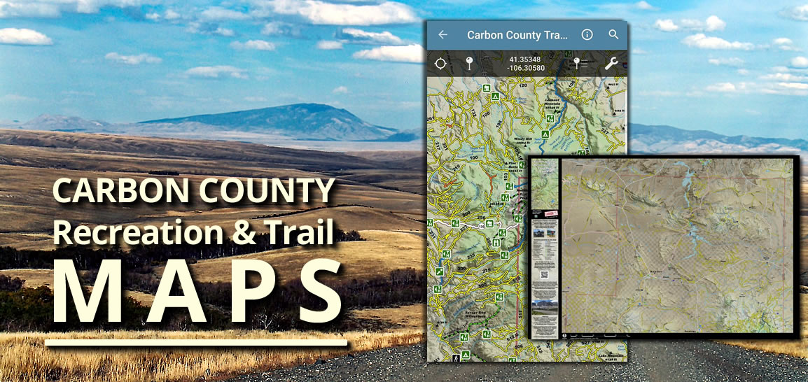
CCVC has created two maps: one of Northern Carbon County and one of Southern Carbon County. “These maps encompass all of Carbon County’s outdoor assets and activities! There are three ways to see the map: on our website, through the Avenza map app for smart phones, or CCVC has a limited number of water resistant print maps available for purchase.” said Leslie Jefferson, Executive Director of CCVC. The printed maps detail the northern half of Carbon County on one side and the Southern half on the other. Similarly, the online and Avenza maps will detail our county in two maps.
 Since a lot of the county is out of cell phone range, the free Avenza version is great a resource.
The Avenza map app works on all smart devices, it doesn’t need a cell signal, and is a must have for anyone venturing into the backcountry of the county. The easiest way to get the Carbon County map on your smart phone is to download the free Avenza App onto your phone, then surf over to our website at www.wyomingcarboncounty.com, click on resources, then maps, and click on the free copy of the maps from Avenza link. It will load our Carbon County maps in the “My Maps” in your Avenza app.
Another exciting perk to the mapping project is the online interactive map, which is a huge plus in trip planning.
The interactive map series will feature multiple recreation-focused maps for hiking, bicycling, camping, fishing, hunting, motor & water sports, and scenic/historic sites. Each recreation map will highlight important trailheads and activity features specific to that recreation. For example, the hiking map will highlight trailheads adjacent to wilderness areas, and the hunting map includes land ownership features for determining private vs. public areas. The maps will have pop-up windows for each recreation feature and road. Each pop-up will have a brief summary of the feature or road and a link to the owning agency’s specific website for that particular feature. These features will enable you to get focused information about your area of interest using a geographic map, rather than figuring out a campsite name then googling around for it. Interactively, you will be able to change the base map to have satellite imagery, USGS topographic, or basic public streets. Other tools for the map will include distance measurement, drawing, and link sharing so you can tell your friends where you’re camping.
The interactive map will be an excellent resource for our residents and visitors alike. The expected launch date for the interactive map is September 30.
How to get started:
On your phone:
1) Download the free Avenza Map app from the App Store or Google Play


2) Download the maps from Avenza here: https://store.avenza.com/products/carbon-county-summer-recreation-western-expanse-inventory-cartography-map
Pick up a map at the Carbon County Visitors Council office:
1) Stop by our office at 105 E Cedar in Rawlins WY.
2) Pick up a water resistant area map - available for purchase only.
On our website:
1) Visit our maps page here: http://www.wyomingcarboncounty.com/resources/maps
2) Pick from Carbon County North or Carbon County South